Ria Formosa Natural Park: A Guide to the Algarve's Wildest Coastline
Everything you need to explore Ria Formosa Natural Park — walking trails, barrier islands, flamingos, seahorses, salt pans, and the best ways to experience Portugal's coastal lagoon.
Solar Alvura
8 May 2026
You'll hear it called one of the Seven Natural Wonders of Portugal, and that's true — it made the list in 2010 after a national vote. But the label doesn't quite prepare you for what Ria Formosa actually is. It's not a single place. It's a shifting, breathing system of lagoons, tidal channels, salt marshes, mudflats, and barrier islands that stretches roughly 60 kilometres along the eastern Algarve coast, from Ancão near Faro all the way east to Manta Rota.
Roughly 18,400 hectares of it. And most visitors to the Algarve don't see any of it.
They fly into Faro, drive west to the cliffs and caves around Lagos, and go home thinking they've seen the coastline. They haven't — not this part, anyway. The eastern Algarve's coast is flat, quiet, and strange in the best way. The tides rearrange the landscape twice a day. Flamingos stand in the shallows like they own the place (they do, more or less). And the barrier islands — five of them — have some of the emptiest beaches in southern Europe.
Here's how to actually experience it, whether you've got a morning or a week.
The Lagoon System: What You're Looking At
Before heading in, it helps to understand what Ria Formosa is — because it's not obvious at first glance.
It's a barrier island lagoon system. Five sandy islands (Barreta, Culatra, Armona, Tavira, and Cacela) sit off the coast like a broken necklace, shielding the mainland from the open Atlantic. Between the islands and the shore: a labyrinth of tidal channels, salt marshes, mudflats, and shallow lagoons that flood and drain with the tides.
The whole thing is constantly moving. Inlets open. Sand shifts. Islands migrate westward at roughly a metre and a half each year — barely noticeable in a human lifetime, dramatic in geological terms. The 2011 breach that created a new inlet near Cacela Velha? That's not a disaster. That's just what barrier island systems do.
This dynamism is exactly why the park supports such extraordinary biodiversity. More than 200 bird species use the lagoon system — some breeding, some wintering, many stopping over during migration between Europe and Africa. Two species of seahorse (the long-snouted Hippocampus guttulatus and the short-snouted Hippocampus hippocampus) maintain populations here that researchers have been tracking for decades, though numbers have declined sharply since the early 2000s. In 2020, two protected safe havens were established within the lagoon to help slow that decline.
And then there's the Mediterranean chameleon. Shy, slow, impossible to spot unless you know where to look. One of the rarest reptiles in Portugal, quietly hanging on in the scrubland and dunes.
Walking the Trails
The walking is flat. Almost all of it. If you've hiked the Cerro de São Miguel trail above Moncarapacho (which starts at 411 metres and involves proper climbing), this is the opposite experience — sea-level paths through salt marsh and dune, with the occasional boardwalk over tidal mud.
The Ludo Trail is where most people start, and rightly so. It begins near Faro airport (yes, the same airport — you can practically see the runway) and runs about 7 kilometres through saltpans and lagoon edge. Don't let the airport proximity put you off. Within ten minutes of walking you're surrounded by nothing but water, reeds, and birds. Flamingos feed in the salt pans here from late autumn through early spring. Egrets year-round.
The São Lourenço Trail runs about 3.5 kilometres from Quinta do Lago through pine woodland and wetland, with interpretation panels and decent birdwatching hides. It's the most "managed" trail in the park — paved in stretches, well-signposted, popular with families. Good for a first visit. Not particularly wild.
The Olhão waterfront paths run east along the lagoon edge from the town centre, past the salt pans and oyster beds. There's no formal trail name — just follow the waterfront and keep going. After about 2 kilometres the town falls away and it's you, the mudflats, and whatever birds are working the shallows. At low tide, you'll see women gathering clams by hand in the mud — mariscadoras — continuing a practice that's been sustaining families here for generations.
The Cacela Velha loop (far eastern end of the park) is the quietest option. The village itself sits on a cliff overlooking the lagoon, and from there you can drop down to the beach and walk the sand spit. In autumn, the light here in the hour before sunset is absurd. Bring a camera. Or don't — you'll remember it regardless.
All trails are free. No permits. No booking. Wear shoes you don't mind getting sandy or muddy (the tidal sections are unpredictable), and carry water — shade is rare once you're out on the marshes.
The Barrier Islands
Five islands. Each one different. None of them have cars.
Ilha da Barreta (Deserta) is the most southerly point of mainland Portugal, technically. Accessible by boat from Faro's marina (about 30 minutes). It's the quietest of the five — just sand, sea, a single restaurant (Estaminé, which is excellent and bizarrely sophisticated for a desert island), and whatever birds are nesting. The beach faces the open Atlantic and runs for several kilometres in both directions. On a weekday in May, you might have it to yourself.
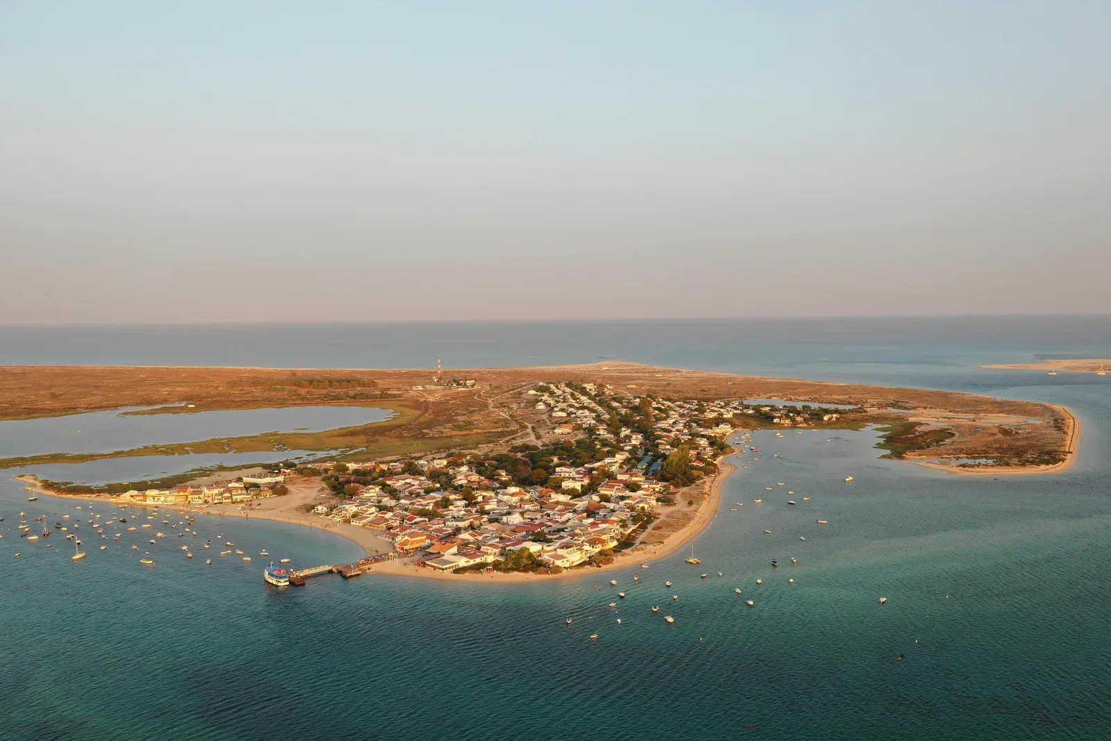
Ilha da Culatra is the one with a soul. Unlike Barreta, Culatra has a permanent fishing community — a village with narrow streets, a small church, a primary school, fishermen mending nets. Walk through the village to Praia da Culatra on the ocean side: wide, white, and gorgeous. The restaurants here serve fish that was in the water that morning. Literally — the boats come in while you're eating lunch.
Ilha da Armona is the closest to Olhão and the easiest to reach. Ferries run roughly every hour in summer (every two hours off-season). It has a small settlement of holiday cabins near the dock, and from there the beach stretches east for kilometres. Walk fifteen minutes from the ferry and you'll have more space than you know what to do with.
Ilha de Tavira is the largest and the most developed (which still isn't very developed). It's accessible from Tavira town, and the ocean beach is popular in summer — bring an umbrella and get there early in July and August. The lagoon side has a campsite and quieter stretches.
Cacela Velha beach functions like a sixth island — it's a sand spit below the hilltop village, accessible at low tide by wading across a shallow channel. That crossing is half the fun. The water is knee-deep, warm, and you emerge onto one of the most photogenic beaches in the Algarve with almost nobody on it.
Ferries from Olhão depart from the marina to Armona, Culatra, and Farol (the lighthouse end of Culatra island). Tickets are sold at the dock, and you should arrive about 30 minutes before departure. Schedules shift with the season — in summer there are frequent crossings; in winter, you're down to a few per day. The NextFerry app is worth downloading to check departures by date and time. Round trips cost a few euros.
The Salt Pans and the Clam Gatherers
Between Olhão and Tavira, the salt pans stretch along the lagoon like a patchwork quilt of shallow pools. Salt has been harvested here since Roman times. The process hasn't changed much: seawater is channelled into progressively shallower pans, the Algarve sun does the rest, and workers called marnotos rake the crystals by hand with wooden tools.
Visit in July or August and you'll see the harvest in full swing. The flor de sal (flower of salt) — the delicate top crust that forms on still days — is the most prized product. It's what you'll find on restaurant tables across the Algarve, and it tastes different from industrial salt in a way that's hard to describe until you try it side by side. Slightly mineral. A bit sweet. Worth buying a bag from one of the roadside producers.
The clam and cockle gatherers are harder to time. They work the tidal flats when the moon and the tide cooperate, often at dawn, wading into the mud with buckets and short knives. Spring tides expose the harvesting grounds for four or five hours at a stretch. When you eat amêijoas à Bulhão Pato (clams with garlic and coriander) at a restaurant in Olhão, this is where they came from. Knowing that changes the dish.
On the Water: Kayaks, Boats, and Paddleboards
Walking the trails gives you the edge of Ria Formosa. Getting on the water puts you inside it.
Kayak tours are the best way to explore the tidal channels up close. Several operators run guided trips from Olhão and Faro — typically two to three hours, paddling through channels that are too narrow and shallow for motor boats. You'll pass oyster beds, see herons at eye level, and hear the strange sucking sound the mud makes as the tide drops. No experience needed. Prices start around €30-40 per person.
Eco boat tours depart from Olhão marina and Faro. These are small-group trips (usually 6-12 people) on traditional wooden boats or low-impact vessels, covering the lagoon, salt marshes, and sometimes a stop on one of the islands. Tours run from about €15-30 per person. The birdwatching-focused tours are the ones to book if you care about what you're looking at rather than just floating past it.
Stand-up paddleboarding works well in the calmer lagoon channels, especially in the early morning before any wind picks up. A few operators offer SUP tours that combine paddling with a swim stop on a sandbar.
One note: the tidal currents in Ria Formosa are real. They're not dangerous for a guided tour, but they're strong enough that paddling against a dropping tide will humble you. Trust your guide on timing.
When to Go (and What You'll See)
Ria Formosa is genuinely year-round, but the experience shifts with the seasons.
Spring (March–May) is peak birdwatching. Migratory species are moving through — spoonbills, avocets, terns, bee-eaters — and the resident breeding colonies are active. The weather's warm enough for comfortable walking (18-24°C) but cool enough that you're not wilting on shadeless trails. The islands are quiet. Wildflowers in the dune scrub. This is the sweet spot.
Summer (June–August) brings the crowds to the beaches, but the lagoon paths stay empty. The salt harvest is underway. The light is intense — go early or late. The ferries run frequently. Sea temperature hits about 21°C in August.
Autumn (September–November) is flamingo season. The colonies build through October and peak in winter. Migratory birds are heading south. The tourist numbers drop sharply after mid-September and the trails feel almost private.
Winter (December–February) is quieter still. Flamingos are at their most numerous. Temperatures stay around 14-17°C — comfortable for walking, though the wind off the lagoon can bite. Fewer ferries. Fewer people. The light is soft and low, and the landscape takes on a melancholy beauty that's harder to photograph but easy to feel.
Getting There from Solar Alvura
Solar Alvura sits in Moncarapacho, about 6 kilometres north of Olhão — which is one of the main gateways to the park. The Olhão marina, where ferries depart for the barrier islands and most boat tours launch, is a 10-minute drive. The Ludo Trail near Faro is about 25 minutes. Cacela Velha is 30 minutes east.
There's no entrance fee to Ria Formosa Natural Park. No ticket booth. You just walk in. That accessibility is part of its character — and part of why it still feels like a local secret rather than a tourist attraction.
We can help arrange kayak tours, birdwatching guides, or island day trips from the hotel. Ask at reception or check our activities page for what's running during your stay.
FAQ
How big is Ria Formosa Natural Park?
The park covers approximately 18,400 hectares and stretches about 60 kilometres along the eastern Algarve coast, from Ancão (near Faro) to Manta Rota (near the Spanish border).
Can you visit Ria Formosa for free?
Yes. The park has no entrance fee. All walking trails are free and open year-round. You'll only pay for ferry crossings to the barrier islands (a few euros return) or guided tours.
What is the best time of year to visit Ria Formosa?
Spring (March–May) for birdwatching and wildflowers, autumn (September–November) for flamingos and quiet trails, summer for beach days on the barrier islands. Winter is the least crowded and best for flamingo photography.
Are there flamingos in Ria Formosa?
Yes — greater flamingos are present year-round but most numerous between November and March. The salt pans between Olhão and Tavira are the best spots. You don't need binoculars to see them, though binoculars help.
How do I get to the Ria Formosa islands from Olhão?
Ferries depart from the Olhão marina to Armona, Culatra, and Farol. Buy tickets at the dock about 30 minutes before departure. Schedules vary by season — the NextFerry app has up-to-date departure times.
Is Ria Formosa good for kayaking?
Excellent. The tidal channels are sheltered and navigable by kayak, with several operators running guided tours from Olhão and Faro. Tours typically last 2-3 hours and cost €30-40 per person. No experience needed.
Solar Alvura
Ready to Experience the Algarve?
Discover our intimate boutique hotel in the heart of the Algarve — sun-drenched days, starlit nights, and memories to last a lifetime.
Book Your Stay